Home page
Council Library
Historical Archives


Write to the Council


© 2000
Comune di Vignola
All rigths reserved
Biblioteca Comunale 'Francesco Selmi'


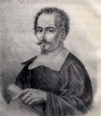
Portrait of Giacomo Cantelli
Giacomo Cantelli - Cartographic fund (1643-1695)
It groups together practically all the maps of the Vignola map-maker printed in Rome at the famous De Rossi cartographic workshop and forming part of the “Mercurio Geografico”. Numerous maps are water coloured or feature precious scrolls containing indications of the contents of the maps and any dedications to princes, monarchs or important persons.


Summary of the most significant maps:
61. 59. Isola e Regno di Sicilia 1682 (colorata) 77. 73. Albania Propria overo Superiore, Roma, Gio. Giacomo de Rossi, 1689 68. 65. Dalmatia marittima occidentale Dalmatia marittima orientale, Roma, Gio. Giacomo de Rossi, 1689 (2 c.) 54b. 53 a. L'Italia con le sue Poste e Strade Principali, Augusta, M. Seutter, 1740? (colorata)

All the images are available on CD-ROM at higher quality;
the catalog of the "Giacomo Cantelli SERENISSIMO geograph" is available
For information click here.


List of Giacomo Cantelli's geographical maps (1643 - 1695)